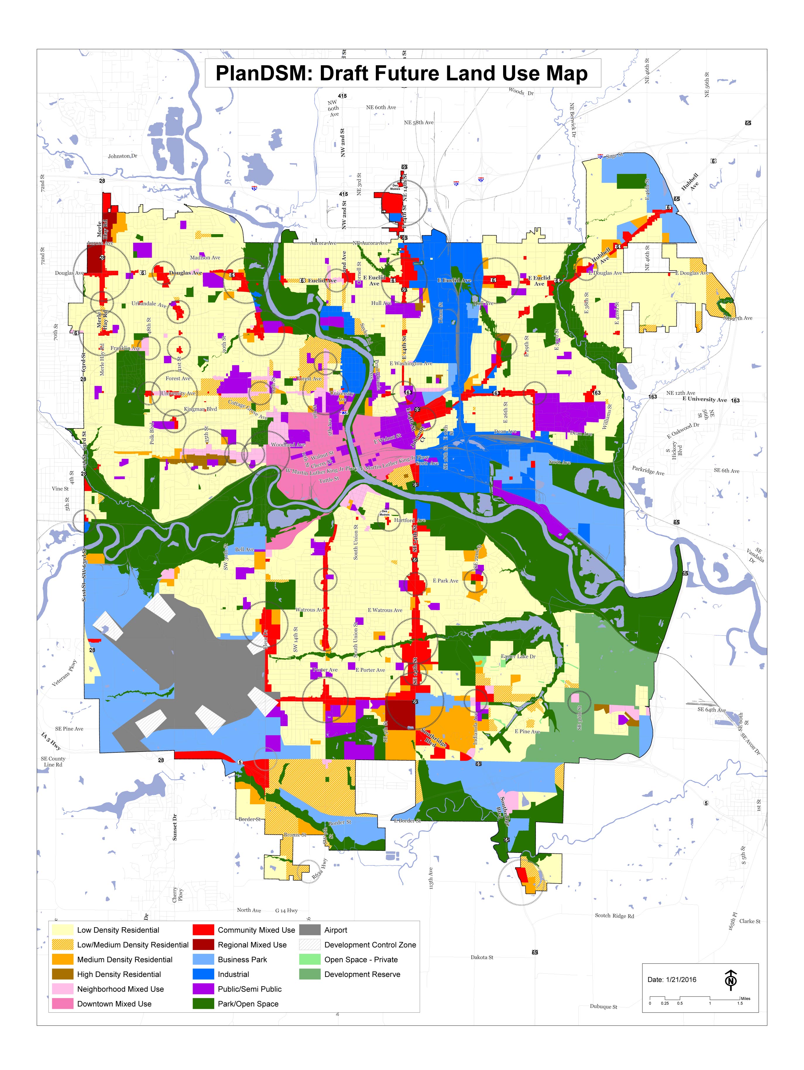
FUTURE LAND USE MAP DESIGNATIONS - DRAFT
This section describes the Future Land Use Map for the City and describes the land use classifications used on the map. The Future land Use Map provides direction to the regulatory structure that implements PlanDSM including the City’s Zoning Ordinance. It shows how and where the City will provide for a variety of housing densities and types as well as commercial and industrial uses.
LOW DENSITY RESIDENTIAL
Areas developed with primarily single family and two family residential units with up to 6 dwelling units per net acre.
LOW-MEDIUM DENSITY RESIDENTIAL
Areas developed with a mix of single family, duplex and small multi-family units up to 12 units per net acre.
MEDIUM DENSITY RESIDENTIAL
Areas developed with mix of single family, two family and multi-family residential up to 17 dwelling units per net acre.
HIGH DENSITY RESIDENTIAL
Areas developed with primarily higher intensity multi-family housing with a minimum density over 17 dwelling units per net acre.
NEIGHBORHOOD MIXED USE
Small scale mixed use development typically located at the intersections of collector and/or arterial streets and along transportation corridors. Non-residential development is designed to serve the immediate neighborhood and include small retail, offices, restaurants and bars, and service oriented development.
COMMUNITY MIXED USE
Small- to medium-scale mixed use development, located on high capacity transit corridors or at the intersection of transportation corridors. Community mixed use areas include both a mix of residential densities and a mix of retail and service establishments designed to attract customers from a large service area encompassing multiple neighborhoods and may include specialty retail that attracts regional customers.
REGIONAL MIXED USE
Large-scale mixed use development, located on or at crossroads of major transportation corridors, emphasizing commercial, retail, and parking. Medium to high density residential may be incorporated within a development or along edges as transition to adjacent lower density residential. Mixed use may be horizontal as well as vertical, so there is no requirement that every building be mixed. May emphasize active uses (e.g. retail) on the ground floor, particularly at key intersections.
DOWNTOWN MIXED USE
Allows mixed-use, high density, and compact combinations of pedestrian-oriented retail, office, residential, and parking in downtown. Mixed use may be horizontal as well as vertical, so there is no requirement that every building be mixed. Should include active uses (e.g. retail) on ground floor, particularly at key intersections.
COMMERCIAL
Accommodates a broad range of commercial uses, including retail, services, and some office. This designation is reserved for areas less suited for mixed use development.
BUSINESS PARK
Accommodates light industrial, office and employment uses along with limited complementary retail uses. Industrial uses in this category would produce little or no noise, odor, vibration, glare, or other objectionable influences and would have little or no adverse effect on surrounding properties.
INDUSTRIAL
Accommodates industrial development and limited supporting commercial uses. Development in this classification could have a large impact on adjoining properties and the environment which would need to be mitigated.
PARKS AND OPEN SPACE
Land or water areas generally free from development. Primarily used for park and recreation purposes but may also indicate open spaces reserved for natural resource conservation.
INSTITUTIONAL
Accommodates public and semi-public uses, including schools, libraries, emergency services, hospitals, civic and government buildings, college campuses, auditoriums, stadiums, museums, places of worship, service providers, and transportation centers. Some smaller, less intensive uses may be incorporated into a Neighborhood or Community Mixed Use designation.
PUBLIC / SEMI-PUBLIC
Areas that are mostly open to public use or public access. May include government facilities, schools, hospitals, libraries and community facilities.
AIRPORT
Includes all facilities related to the operation of the Des Moines International Airport including those of tenants on airport property.
DEVELOPMENT CONTROL
Areas that are sensitive to development, such as airport runway approach areas, floodplains, wildlife corridors, etc.
ECOLOGICALLY SENSITIVE RESERVED ZONE
Areas where development of any kind is prohibited, e.g. floodplains, environmentally sensitive lands and slopes
DEVELOPMENT RESERVE
Accommodates areas within city’s corporate limits that are currently underserved or not served by public infrastructure.
Three overlay districts are also identified on the Future Land Use Map representing neighborhood, community and regional nodes. Not all characteristics of nodes exist today but these areas represent opportunities to develop a mixture of uses to provide a variety of housing types, employment opportunities and services at greater concentrations than the surrounding area. Nodes are focal points in the community and do not represent a specific spatial area. Nodes exist today. However, they are largely auto-oriented places. Neighborhood, Community and Regional nodes represent opportunities over time for the City to create mixed use areas that provide for increased housing and transportation choices, reduced infrastructure and maintenance expenditures and the creation of vibrant places to serve neighborhoods and the City as a whole.
NEIGHBORHOOD NODE
These nodes are the smallest in size and offer services that provide for basic daily needs of the local population in the surrounding neighborhood. May include restaurants, shops and smaller scale businesses.
COMMUNITY NODE
Mid-sized centers providing a range of daily needs and specialized services within a larger neighborhood context. Consist of a mix of housing, retail and offices serving a larger population and geographical area than a neighborhood node. May include a shopping district including a grocery and drug store.
REGIONAL NODE
The largest node, regional nodes are concentrations of employment, retail and housing and may include light industrial uses. They serve the widest geographical area and attract people from throughout the City and region.
